


GPS Module
Gumstix make a GPS enabled add-on board, this page give some details in using it.
The GPS Module
The GPSStix expansion includes a GPS module.
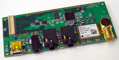
Gumstix GPS and Audio Module
The GPS Module uses the Standard UART (STUART). This can be accessed via /dev/ttyS2.
> stty -F /dev/ttyS0 9600 -icrnl
> cat /dev/ttyS2
$GPZDA,140123.00,17,02,2009,00,00*6C
$GPRMC,140124.00,A,5356.73777,N,00103.23273,W,0.567,92.13,170209,,,A*4D
$GPVTG,92.13,T,,M,0.567,N,1.052,K,A*06
$GPGGA,140124.00,5356.73777,N,00103.23273,W,1,06,1.43,22.3,M,47.4,M,,*7B
$GPGSA,A,3,13,32,23,12,11,31,,,,,,,2.87,1.43,2.48*04
$GPGSV,2,1,08,20,79,083,13,13,23,193,28,17,45,250,25,32,51,074,28*7E
$GPGSV,2,2,08,23,49,175,30,12,07,344,27,11,33,146,29,31,22,059,31*7B
$GPGLL,5356.73777,N,00103.23273,W,140124.00,A,A*7A
$GPZDA,140124.00,17,02,2009,00,00*6B
$GPRMC,140110.00,A,5356.73782,N,00103.23277,W,0.39
GPS Codes
The data output from the GPS modules is tagged with codes defined by the NMEA standard. The table below gives a description of some of these. There is a lot more information available from http://home.mira.net/~gnb/gps/nmea.html.
| Code | Description |
|---|---|
| GPGGA | Global Positioning System Fix Data (This is probably the most interesting) |
| GPGLL | Geographic Position, Latitude / Longitude and time |
| GPGSA | GPS DOP (Dilution of Precision) and active satellites |
| GPGSV | GPS Satellites in view |
| GPRMC | Recommended minimum specific GPS/TRANSIT data |
| GPVTG | Track Made Good and Ground Speed |
| GPZDA | UTC Date / Time and Local Time Zone Offset |
GPS Data Reading Program
The data sent by the GPS module has a well defined structure so reading it
in isn't too complicated. Below are three c files to demonstrate one approach.
gps.h and gps.c give a set of handy functions for
parsing the GPGGA data. gpsTest.c shows how to read
from the GPS data from the serial port.
A simple make file is included to help you get the code compiled.
gps.htypedef struct { int degrees; int mins; int minFrac; char quadrasphere; } DMData; typedef struct { DMData latDM; DMData longDM; int quality; int numSats; int checkSum; } GPSData; void printGPSData(GPSData *gpsData); int hexStr2Int(char* str, int sPos, int numChars); int extractNum(char* str, int sPos, int ePos, int *valPtr); int decodeGPSString(char *str, GPSData *gpsData);
gps.c#include <stdio.h> #include "gps.h" // $GPGGA,hhmmss.ss,ddmm.mmm,a,dddmm.mmm,b,q,xx,p.p,a.b,M,c.d,M,x.x,nnnn // hhmmss.ss UTC of position // ddmm.mmm Latitude of position // a N or S, latitutde hemisphere // dddmm.mmm Longitude of position // b E or W, longitude hemisphere // q GPS Quality indicator (0=No fix, 1=Non-differential GPS fix, 2=Differential GPS fix, 6=Estimated fix) // xx Number of satellites in use // p.p Horizontal dilution of precision // a.b Antenna altitude above mean-sea-level // M Units of antenna altitude, meters // c.d Geoidal height // M Units of geoidal height, meters // x.x Age of Differential GPS data (seconds since last valid RTCM transmission) // nnnn Differential reference station ID, 0000 to 1023 void printGPSData(GPSData *gpsData) { printf("Lat: %dd %d.%d' %c, Long: %dd %d.%d' %c, Sats: %d, Checksum: %02X\n", gpsData->latDM.degrees, gpsData->latDM.mins, gpsData->latDM.minFrac, gpsData->latDM.quadrasphere, gpsData->longDM.degrees, gpsData->longDM.mins, gpsData->longDM.minFrac, gpsData->longDM.quadrasphere, gpsData->numSats, gpsData->checkSum); } int hexStr2Int(char* str, int sPos, int numChars) { int val = 0; while (numChars > 0) { int d = str[sPos] - 48; if (d>9) d -= 7; val = (val << 4) + (d & 0xF); sPos++; numChars--; } return val; } int extractNum(char* str, int sPos, int ePos, int *valPtr) { int val = 0; for ( ; sPos<=ePos ; sPos++) { if (str[sPos] > 57 || str[sPos] < 48) return 1; val = (val*10) + str[sPos] - 48; } *valPtr = val; return 0; } int decodeGPSString(char *str, GPSData *gpsData) { const char *code = "$GPGGA"; int i; // Check for the correct code for (i=0 ; i<6 ; i++) if (str[i] != code[i]) return 1; int pos = 1; int commaPos[14]; int commaCount = 0; int starPos = 0; int nlPos = 0; char checkSum = 0; // Iterate through string characters while (pos < 100) { // Check for end of line if (str[pos] == '\n') { nlPos = pos; break; } // Check for star and update checksum if (starPos == 0) { if (str[pos] == '*') starPos = pos; else checkSum ^= str[pos]; } // Check for comma if (str[pos] == ',') { if (commaCount < 14) commaPos[commaCount] = pos; commaCount ++; } pos ++; } // Check for sensible format if (starPos==0 || nlPos==0 || commaCount!=14 || (nlPos-starPos)!=4) return 2; // Compare Checksums gpsData->checkSum = hexStr2Int(str, starPos+1, 2); if (checkSum != gpsData->checkSum) return 3; // Extract Latitude int err = 0; err |= extractNum(str, commaPos[1]+1, commaPos[1]+2, &gpsData->latDM.degrees); err |= extractNum(str, commaPos[1]+3, commaPos[1]+4, &gpsData->latDM.mins); err |= extractNum(str, commaPos[1]+6, commaPos[1]+10, &gpsData->latDM.minFrac); gpsData->latDM.quadrasphere = str[commaPos[2]+1]; if (err) return 3; // Extract Longtude err = 0; err |= extractNum(str, commaPos[3]+1, commaPos[3]+3, &gpsData->longDM.degrees); err |= extractNum(str, commaPos[3]+4, commaPos[3]+5, &gpsData->longDM.mins); err |= extractNum(str, commaPos[3]+7, commaPos[3]+11, &gpsData->longDM.minFrac); gpsData->longDM.quadrasphere = str[commaPos[4]+1]; if (err) return 4; // Extract Quality err = extractNum(str, commaPos[6]+1, commaPos[7]-1, &gpsData->quality); if (err) return 5; // Extract Number of Satelites err = extractNum(str, commaPos[6]+1, commaPos[7]-1, &gpsData->numSats); if (err) return 6; return 0; }
gpsTest.c#include <stdio.h> #include "gps.h" int main(void) { char buffer[200]; GPSData gpsData; FILE *fp; fp = fopen("/dev/ttyS2", "r"); while (1) { if (fgets(buffer, 100, fp) == NULL) { printf("Got NULL\n"); break; } if (ferror(fp)) { printf ("Error Reading\n"); break; } int result = decodeString(buffer, &gpsData); if (result == 0) printGPSData(&gpsData); } fclose(fp); return 0; }
Makefile# Gumstix GPS Makefile CC = /files/gumstix/gumstix-oe/tmp/cross/bin/arm-angstrom-linux-gnueabi-gcc CFLAGS += -Wall OBJS = gps.o gpsTest: gpsTest.c $(OBJS) $(CC) $(CFLAGS) $(INCLUDE) $(OBJS) -o gpsTest gpsTest.c gps.o: gps.c gps.h $(CC) $(CFLAGS) $(INCLUDE) -c gps.c
